- 71 Posts
- 113 Comments


 3·9 days ago
Spoken like a true geologist.
It’s a small boulder, comparable in length to the diameter of Percy’s wheels, I’d estimate - so the long dimension is roughly 50 cm. Here’s one of the HazCam shots that Paul Hammond assembled, from sol 1642:

Please keep the questions coming, everyone - they’re helping me put together my
link dumpreference list! (I’m not promising a FAQ any time soon, but that’s the way this really should go, ultimately…)

You needn’t be concerned. Deimos isn’t going to activate your latent lycanthropy.
It’s Phobos you need to worry about.
Of course, all of us here are concerned that the filthy extrasolar ETs may have arranged this close cometary flyby of Mars… in order to launch an invasion.
I told NASA, I told them before the rovers launched!, that Percy and MSL should be carrying much higher wattage lasers. I guess it’s fine for the Perseverance team to “sample” a few sandworms so that the drivers can relieve their boredom, although I think they need to improve their aim - still, it’s a lot more humane than what Curiosity does to felines. But now, even before we can return Percy’s samples to Earth, it might just be aliens.
No, I don’t have a source for this; what, don’t you trust me? Come on, this is 2025, we all know this is anything but a normal year…
makes its closest pass by Mars on Oct. 3 at a distance of about 17 million miles, or 28 million kilometers
Comet Siding Spring passed Mars at a much closer distance back in 2014 (< 150,000 km), with the comet passing between the planet and the Sun (i.e. over the dayside). The meteor shower was reputedly very intense, but I don’t recall reports from the rovers about effects visible on the ground. I can’t find a source indicating the time of closest approach to Mars, so I don’t know if Percy or Curiosity will stay up late trying to photograph this comet, but the press release says the rover will be trying to take some data, at least. Freaky times!
Sunrise on sol 1639 was circa 05:20 LMST. I note that Percy was active before sunrise on 1638 as well, with some PIXL imaging of abrasion patch #46. We’ve seen early morning imaging activity in other recent sols as well, so - perhaps we should not be entirely surprised? I do share your puzzlement, however, Paul.
There was a full suite of multispectral imaging on this interesting clast back on 1626, albeit at noontime, and the very same light-toned close-up target was viewed by SuperCam RMI on that sol as well. Given the fairly rapid pace of operations in this Vernodden region, with the rover making abrasions at a steady pace, then moving on, I don’t find it surprising in retrospect that we would do follow-up imaging on a target like this, now that we’ve doubled back to patch #46.

I’m not surprised that the science team has returned to abrasion #46, given the evident signs of alteration by water in this rock, such as the mineral veins:
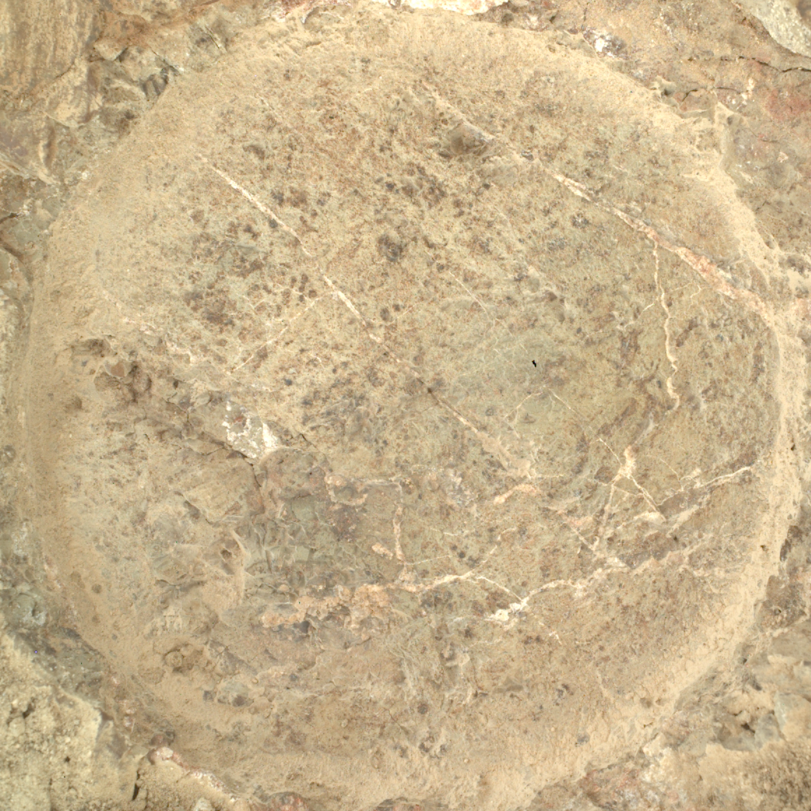
Of the 19 abrasion patches we’ve made on this immense crater rim, this is the first one to betray such obvious visual evidence of fluid flow, though others have seen strong aqueous alteration as well. Might Percy attempt to sample here? We’ve only got 8 unused sample tubes left, but this place has proven very interesting…
You mean the objective of the abrasion? The point is to remove the outer surface of the rock.
As you can see, the abraded part (inside the circle) is very different from the unabraded/natural part (outside the circle). The natural surfaces of these rocks have been sitting out in the weather for billions of years - they’ve been worn down by endless wind, sandblasting, radiation and even the tiny bits of moisture that the Martian atmosphere still has to offer. The geologists generally want to analyze the original, “fresh” parts of the rock which haven’t been exposed to weathering, which you can get by drilling into the inside.
Hope this is clear enough. Feel free to ask if you’ve further questions.
 3·24 days ago
Water. It gets everywhere. Even here, on Mars - always popping up where you least expect it. And it comes super-saturated - 10,000,000 times super-saturated.
It’s insidious.
Here’s the relevant abstract from the European Planetary Science Congress where this research was presented:
The Arsia Mons Elongated Cloud (AMEC) is an eye-catching and mysterious cloud occurring recurrently every morning during the perihelion season over the Arsia Mons volcano on Mars. It shows a peculiar elongated shape that in only 3 hours expands up to 1800 km from its origin point.
This provides an excellent explanation for this mysterious cloud and shows that homogeneous nucleation is possible and can have significant effects in the atmosphere of Mars, contrary to the widespread assumptions during the last twenty years of Mars exploration. The finding of supersaturations up to 108 in the surveys performed by Fedorova et al. (2020; 2023) observationally supports that these extreme supersaturations can indeed happen in the atmosphere of Mars and homogeneous nucleation could be happening in other clouds.

I find these tall tales and conspiracy theories deeply offensive. Why can’t you bring some objectivity and scientific rigour to this community?
Everyone knows that Martian sandworms wouldn’t simply discard a big hunk of mineralized biomatter like your “deviljho skulls” - they’d consume it right alongside the weak flesh of whatever lesser monster they happen to encounter. Rocks like this are clearly indigestible by the worms. Besides, the rover is way too high above the sandy flats (see below) to worry about those things.

As if the rover drivers would ever let those things get anywhere near Percy.

Worth noting that the rover has now been investigating this little stretch of hillside for 28 unbroken sols (Percy hasn’t left a tight zone about 20x20 m across for 23 sols now).
Only one other part of the rim has seen this kind of dedicated interest (the area where we took samples #26 and #27, just below the rim summit/ridgeline); Percy made two abrasions there, but only after the area was first briefly scouted, passed, then returned to. In the current area, the rover has made three abrasions just a few metres apart - the only place where it has done so all mission long. A casual review of the rover’s traverse over the last 18 months shows just one other area where Percy continuously lingered so long - the northern side of the Neretva Vallis channel, where the “potential biosignature” was found.
I am definitely not saying that the science team has identified anything similar here. As far as I can tell, the interest we’re seeing in the current site is partly due to a geologic quirk - the way this crater rim exposes multiple different rock types across short stretches. It could be that the science team is simply running investigations differently now that we only have 8 completely unused sample tubes remaining. That being said, this area clearly has multiple targets worthy of investigation, and the string of short drives we’ve made in the last three weeks indicate that this area is being closely and systematically surveyed. The ridgeline site we investigated earlier this year returned two very different samples: one badly fractured and impact-damaged, the other “softer”, finer-grained, and unmistakably altered by water - heavily so.
So what have we found here so far? The mission hasn’t said much yet, but the dual-sample site I refer to above was studied in just this way, only more briefly - and we can definitely see that water has altered the rock here too, in a way we haven’t see on the rim before (those mineral veins didn’t fill themselves). Stay tuned!

I’m not the best with emojis, so I might be misunderstanding you, but if “pointing finger” means you want to poke this sample - please don’t. The skeptics will say you contaminated them, and then we’ll never hear the end of this “life on Mars” business…
 3·1 month ago
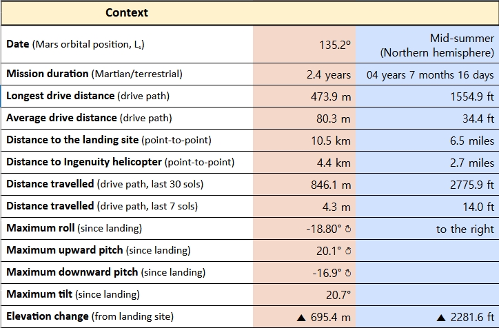
Here’s an example from the Perseverance rover community - it includes details like the length of the drive (in metres and in minutes), the rover’s geographic position, orientation and elevation at the end of the drive, and so on.
We don’t have any information on what the expectations or plans are for the drives when we get this data - that is only reported months later, when planning data is publicly released. Paul Hammond and I are slowly working on making this sort of information more accessible (I’m trying to add annotated maps and context, for example), so if you have any ideas on what you’d like to see from these updates, feel free to share.

NASA will host a media teleconference at 11 a.m. EDT Wednesday, Sept. 10, to discuss the analysis of a rock sampled by the agency’s Perseverance Mars rover last year, which is the subject of a forthcoming science paper.
The sample, called “Sapphire Canyon,” was collected in July 2024 from a set of rocky outcrops on the edges of Neretva Vallis, a river valley carved by water rushing into Jezero Crater long ago.
There was a lot of excitement last year when Percy examined the unusual bedrock on the floor of the Neretva river channel. That material - mostly or entirely soft mud and silt laid down by the former river - had some interesting markings that the science team nicknamed “poppy seeds” (small dark markings in abrasion #25, on the south side of the channel - see here for a close-up) and, on the north side of the channel, “leopard spots” (the small dark spots with light-toned rims, between the coarse white mineral veins, in this image, from the site of abrasions #26 and #27).
It wasn’t long before the Principal Investigator himself, Ken Farley, was identifying this material (which we have obtained as sample #25) as “very important” - even using words like “potential biosignature” in a presentation at CalTech last year (I’ve linked to the relevant portion of the talk, but the entire 33 min video is worth watching). Since August 2024, there have been some small publications about this material, but it appears that we finally have more results and analysis on the docket. I could speculate on what the science team will be presenting, but I’d rather not steal their thunder, so I’ll just leave a link to my (still very rudimentary) guide for the portion of the mission, in and around the river channel, last year.
Several of the brass from NASA HQ, including Trump’s “temporary NASA administrator”, but also several actual senior NASA scientists, will be attending, so don’t miss this one if you’re interested!
It might be amusing to track a mountain goat - you know, like they have on Earth - via GPS, and see if it produces a wandering path anything like the above traverse map. (I intend no insult to goats or rover AIs with this comparison)
Judging from the last two weeks of short drives up the current slope (zoom in on the map above to see what I mean), it would appear that the science team is very carefully documenting the different outcrops/rock types we can see around here.
I’ve only noticed this level of interest concentrated in one small area twice before this year, in two spots further north (Witch Hazel hill), where the rover acquired quite a few samples. Based on the topography, I’m speculating that this layer/set of strata wasn’t exposed further north. No geologist likes a gap in their wedding cake, of course - and that’s even before you consider that the rim of this crater is not recording a gently-deposited set of flat layers, but a wild sequence of different rocks, altered in different ways, and quite possibly at different times. So what we’ve found on the rim already demands we be complete with our investigation; OTOH, it may be that they’ve spotted something interesting in the mineralogy here that warrants this kind of careful mapping.
There is a basic question to be asked here: how much of the these flattish rocks we find on the slope are basically volcanic in origin (as Mars Guy would only be too happy to tell you about), and how much is due to the mind-bending, one-and-done violence of the original Jezero impact, which punched out a basin 50 km across and half a kilometre deep (at the very least)? Though Curiosity has been climbing its mountain for many years, Percy has experienced an elevation change almost as great in its much shorter mission, simply by driving out of the crater and onto the Nili plateau - and Jezero is a fairly modest-sized crater by Martian standards.
When you consider that this landscape might preserve evidence of a much larger impact found far downriver from Jezero (the one that made the Isidis basin, a mere 1500 km across), not to mention the immense age of the Nili countryside, which still shows traces of eruptions originating far underground, the question of “impact vs. volcanism” no longer seems like a small question, but a global one.
I feel small now.
They’ve used artificial lighting on most of the abrasion patches, which is pretty useful for seeing patterns and comparing features across a lot of different rock types:

For comparison, the abrasion patches under natural lighting:

Quick impressions/interpretations (you may need to zoom in on this image):
A - Dark grey pebble: not the first time we’ve seen something like this - a grey pebble embedded in the rock like a chocolate chip in cake batter - but always worth pointing out. Most residents of Earth wouldn’t pay the least attention to this sort of pebble, but you don’t see them on Mars so much, right? This rock fragment appears to be solidly intact and mostly unaltered.
B and C - Small light grey fragments: these ones are very flattened compared to A (likely softer material than fragment A), but don’t display many “spots” of different colour.
D - Small light grey fragment with spots: Compared to A, B and C, there are more “blemishes”, if you will - white flecks and a darker grey spot.
E - Whitish zone: Perhaps something that originally resembled D, now further altered?
The above interpretation presumes that all of the little fragments originally resembled A, which is not a safe assumption, but clearly these little pieces have seen some things and have a story to tell.
Whitish material has often proven to be a soft sulfate mineral, like gypsum, which is a sign of significant alteration by water, after the rock was originally laid down. We’ve seen signs of aqueous activity not far from here, so I wouldn’t be surprised if this is again the case.
One striking thing about all of the fragments in this rock is how rounded they are. Impact breccia (from the asteroid strike that made Jezero Crater) often shows fragments with sharp, angular edges (here’s one example from Earth, or this one, from Luna), thrown out and mixed in by the impact itself. Here, though, it’s hard to find any sharp corners in the embedded fragments. Fun times!